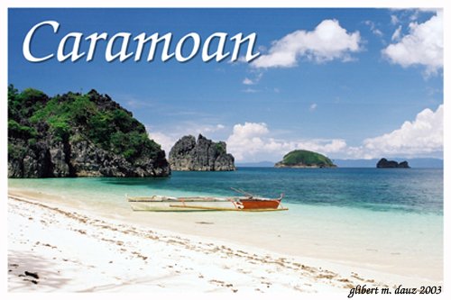
 Gota Beach 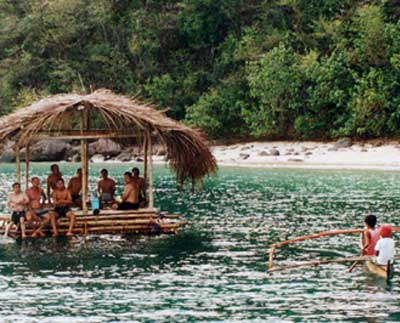 Camarines Sur Beach 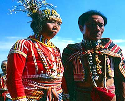 Native Costume 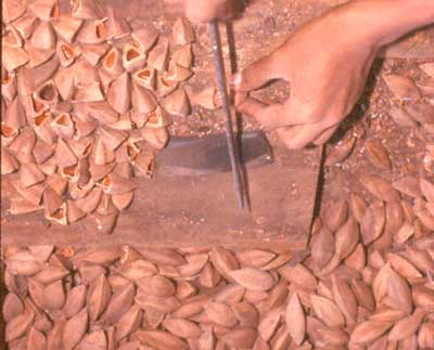 Pili Nut 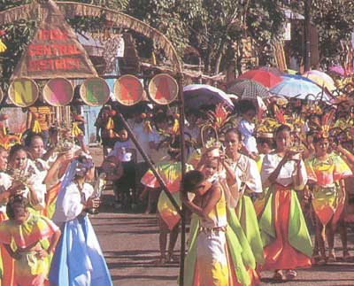 Tinagba Festival | Camarines Sur Paradise in Bicolandia Capital: Pili No. of Towns: 35 Land Area: 5,267 sq. km. Telephone Area Code: 054 Camarines Sur, dubbed as the rice granary (Sp. caramines) of the south (Sp. sur), has been taken for granted as a largely agricultural province. The fertile soil of its planes, however, is but one of this province’s riches. She is also blessed with breathtaking sceneries and lush landscapes. The province is home to two extinct volcanoes, Mts. Isarog and Iriga, which offer prime opportunities for nature lovers and adventurers alike. In addition, being partially bounded on three sides by gulfs and the Pacific Ocean on the north, she boasts of stretches of pristine beaches like Gota in the Caramoan Peninsula and those in the Atulayan Islands in Sagnay. Brief History The province of Camarines Sur actually first came into existence only in 1829. Prior to the edict, which brought this about, the province was part of the region Tierra de Ibalon, later named Los Camarines, which was "discovered" in 1569 by the Spanish expedition led by Capt. Luis de Guzman and Augustinian Friar Alonso Jimenez. Said Spanish expedition was merely exploratory, thus, the serious work of evangelizing the natives became the responsibility of the Franciscan missionaries whose efforts were capped by the founding of the Diocese of Caceres in 1595. The centuries of Spanish occupation in the region was relatively uneventful. Events worth noting are the establishment of the devotion to the Virgin of Peñafrancia by the Spanish secular priest Miguel Robles de Cubarrubias in 1710; and the development of the abaca export industry in 1818 when the Bikol mainland saw the last of the Muslim raiders who had been looting the area for over two centuries. September 17, 1898 saw the end of Spanish rule in Bikol region. This one-day revolt was staged in Nueva Caceres under the leadership of Elias Angeles and Felix Plazo. Within a year and a half, Camarines Sur, then joined with Camarines Norte under the name Ambos (both) Camarines, was once again made subject of foreign rule - this time American - despite the resistance led by Gen. Ludovico Arejola. In this period of forty years, Fr. Jorge Barlin of Baao served as the first Filipino bishop (1905-1909); Ambos Camarines was finally divided into Norte and Sur (1919); agricultural productivity surpassed records under the Spanish regime; and local culture was enriched with the establishment of the public school system, the propagation of the English language, and the thriving of "indigenous and locally adapted foreign arts, music, literature and sciences." This progress was cut off shortly by the Japanese invasion from 1941 to 1945 when engagements between guerillas and the invading army were frequent. Shortly after the liberation of Camarines Sur from the Japanese, Philippine independence from the Americans was declared. Geography Camarines Sur is one of the six provinces comprising the Bicol Region. She lies in the center of the Bicol Peninsula bounded by the province of Albay and Ragay Gulf on the south; Camarines Norte, San Miguel Bay and the Pacific Ocean on the north; Lagonoy Gulf on the east; and the province of Quezon and Ragay Gulf on the west. The people The population is a conglomeration of Bicolanos, Visayans and Ilocanos. The dominant dialect is Bicolano. Migrant dialects have also been brought in. Cultural communities belgonging to the Agta-Tabangnon and Cimaron tribes can be found on the eastern part of the province. Commerce and industy: Camarines sur is basically agricultural. The major crops are cocnut, rice, abaca, banana, rootcrops and vegetables. Mining is growing industry. There are deposits of gold, silver, chromite, copper and other metals in the eastern side. The province also has rich fishing grounds. Cottage industries include bamboocraft in Nabua, emrodery in Baao and fibercraft in the other towns. Tourist attractions: The provencial boundary with Camarines Norte lies within the 52 sq kilometers Bicol Forest NAtional PArk, Libmanan, a 19 hectar national park, inludes Cuapnitan Caves, 19 limestone caves that house thousands of bats. Naga City is in the shadow of Mt. Isarog. Naga Cathedral, built in 1843, is one of the largest churches in the country, it contains a black Nazarene statue. Our Lady of Peñafrancia has two shirnes, the old and the new. The orginal, known as ermita, is an attractive, simple church. the modern one, a short distance across the river, was completed in 1982. The Peñafrancia Festival is held in NAga in September. It features a novena or nine days of devotions at the Naga Cathedral. The actual feastday starts with a penitential procession at dawn and morning boat races on the river. At around noon, the Virgin´s image is carried aboard a gaily decorated casco or barge for a fluvial procession. Pili, the capital 15 km southeast of Naga, is known for Boncao Hill, the last Japanese stronghold in the Bicol region. Iriga is in the shadow of Mt. Iriga. The Tinagba Festival is held here every February 11 as a harvest offering festival to Our Lady of Lourdes. Farmers parade in carabao-drwan carts filled with the best local produce, while Agtas come down from the mountains to dance. The town of Nabua holds the Boa-Boahan Festival every May 2. This reenactment of the 13th century pagan rite of offering chains of coconut embroys called boa to their deities is meant to ensure a prosperous year. The town of Bombon, a few kilometers north of Naga, is noted for its leaning tower. The Ladrillo church of Quipayo in Calabana, further north of Naga, is a unique brick church constructed in 1616. There is a museum behind the altar displaying rare artifacts. The town of Milnor, 3,5 kilometer south of Naga, has a church with an octagonal stone belfry and an antique wooden confessional. Bula and Baao towns farther south both have 18th century churches. Lake Buhi, 16 km from Iriga, is known for tabios or its local name sinarapan, the world´s smallest fish at three to four millimeters long. A spoonful contains a thousand of them. The famous dish made from it is called "Thousand Fish Omelett". Getting there and away: By Land... Camarines Sur is accessible from Manila via the scenic Pan-Philippine Highway. Air-conditioned coaches plying the Manila to Naga route leave the Araneta Center at thirty-minute intervals starting at about 4 pm thru 9:30 pm daily. For tourists coming from the Ermita Center, another set of air-conditioned buses can take you through the same route to Naga. For the weary business traveler, arrive in tip-top shape, sleep through the whole length of the ten-hour trip and for the starving passenger, dine in style, your choices are enormous - a piping hot porridge, the delectable Filipino chicken adobo, or the more cosmopolitan sandwiches. Which way you want it, the buses stop at designated restaurants that serve these kinds of food. By Air... Camarines Sur can also be reached by plane through the Pili Airport. For the Philippine Airlines and Asian Spirit traveler, eager to reach Camarines Sur faster, there is no other way to go but fly. Some Contents from:http://www.adnu.edu.ph/wowphil/index.asp |
Source: Lakbaypilipinas.com
No comments:
Post a Comment